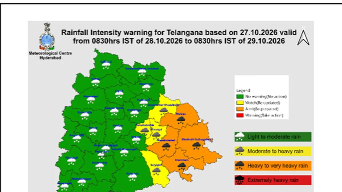
All 33 districts of Telangana are bracing for meteorological disruptions on Wednesday, October 28, 2026, as severe cyclonic storm Arnab edges closer to the eastern coastline of India. According to official advisories published by The Hindu, regional forecasters have placed four eastern districts under an orange alert for heavy to very heavy precipitation, while four neighboring regions remain under a yellow alert for sustained downpours.
Data released by the India Meteorological Department-Hyderabad Centre positioned the cyclonic system approximately 170 kilometers off the coast of Visakhapatnam and 180 kilometers from Kakinada in Andhra Pradesh as of Tuesday morning, October 27, 2026. The storm's rapid trajectory across the Bay of Bengal continues to pull dense moisture inland, directly impacting agrarian belts and major urban centers across central and eastern Telangana.

Districts on High Alert and Flooding Hazards
The IMD bulletin confirms that Mulugu, Bhadradri Kothagudem, Khammam, and Mahabubabad face the highest rainfall intensities under the orange warning umbrella. Municipal administrations have been cautioned about severe municipal disruptions, including the flooding of arterial roads, localized waterlogging in low-lying settlements, and the prospective closure of road underpasses in densely populated urban centers.
Simultaneously, a yellow alert remains active across Jayashankar Bhupalapally, Suryapet, Warangal, and Hanumakonda. Meteorologists warn that thunderstorms accompanied by vivid lightning strikes and gusty surface winds will lash isolated pockets within Jayashankar Bhupalapally, Mulugu, Bhadradri Kothagudem, Khammam, Nalgonda, Suryapet, Mahabubabad, Warangal, and Hanamkonda. Across the remaining districts of Telangana, sporadic surface wind speeds reaching 30 to 40 kmph are forecast through midweek.
| District / Area | Alert Level | Expected Weather Condition | Key Civil Risks |
|---|---|---|---|
| Mulugu, Bhadradri Kothagudem, Khammam, Mahabubabad | Orange Alert | Heavy to very heavy rainfall | Flooded roadways, underpass closures, severe urban waterlogging |
| Jayashankar Bhupalapally, Suryapet, Warangal, Hanumakonda | Yellow Alert | Sustained heavy rainfall, lightning | Saturated drainage systems, localized power outages |
| Greater Hyderabad & Surroundings | General Advisory | Light to moderate rain, 30–40 kmph wind gusts | Overcast skies, periodic transit delays, slippery highways |
| Rest of Telangana (Isolated pockets) | Standard Watch | Thunderstorms and gusty winds | Intermittent squalls, minor tree branch falls |
Municipal Readiness in Greater Hyderabad
For the state capital of Hyderabad and its immediate urban periphery, the weather office forecasts a heavily overcast sky prevailing for at least 48 hours. The city will likely experience recurring bouts of light to moderate rainfall or thundershowers coupled with gusty winds shifting between 30 and 40 kmph.
Civic authorities are urging commuters in vulnerable urban centers to monitor travel advisories closely as drainage networks absorb sustained runoff. Disaster response units across eastern Telangana have initiated emergency monitoring protocols to manage low-lying residential inundations, agricultural runoff, and public transit diversions as Cyclone Arnab completes its coastal approach.