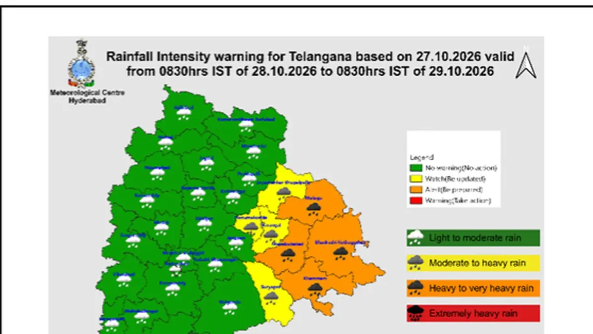
All 33 districts of Telangana are bracing for significant weather disruptions on Wednesday, October 28, 2026, as severe cyclonic storm ‘Arnab’ moves closer to the east coast of India. The India Meteorological Department (IMD) Hyderabad Centre issued an urgent weather advisory warning of widespread precipitation, pinpointing intense downpours across the eastern parts of the state.
According to tracking data released in an advisory reported by The Hindu, the center of the storm was tracked roughly 170 kilometers from Visakhapatnam and 180 kilometers from Kakinada along the Andhra Pradesh coastline on the morning of October 27, 2026. The system’s outer bands are generating substantial moisture surges expected to sweep inland across central and eastern Telangana.
District Alerts and Inundation Risks
Meteorologists have elevated the warning status to an orange alert—denoting heavy to very heavy precipitation—in four specific administrative zones: Mulugu, Bhadradri Kothagudem, Khammam, and Mahabubabad. Forecasters warn that intense, localized downpours could trigger severe surface runoff, flash flooding of regional roadways, rapid water accumulation in low-lying residential settlements, and emergency closures of municipal underpasses.
Adjacent regions have been placed under a yellow alert, indicating isolated heavy rainfall. These districts include Jayashankar Bhupalapally, Suryapet, Warangal, and Hanumakonda. Across these territories, atmospheric instability is projected to generate thunderstorms, frequent lightning strikes, and gusty surface winds reaching sustained speeds between 30 and 40 kmph.
| District / Area | Alert Level | Expected Weather Condition | Primary Risk Factor |
|---|---|---|---|
| Mulugu, Khammam, Mahabubabad, Bhadradri Kothagudem | Orange Alert | Heavy to very heavy rainfall | Inundation of lowlands, underpass closures, road flooding |
| Warangal, Hanumakonda, Suryapet, Bhupalapally | Yellow Alert | Isolated heavy rainfall & thunderstorms | Flash runoff, localized water stagnation, lightning strikes |
| Hyderabad & Greater Environs | General Advisory | Light to moderate rain, gusty winds | Traffic bottlenecks, localized waterlogging over 48 hours |
| Remaining Telangana Districts | General Advisory | Scattered showers, 30–40 kmph winds | Periodic squalls, minor branch fall, isolated lightning |
Hyderabad Outlook and Civic Precautions
State capital Hyderabad and surrounding urban centers are expected to remain under overcast skies through the middle of the week. The IMD Hyderabad Centre stated that municipal limits will likely record light to moderate showers accompanied by gusty winds over a 48-hour window ending late on October 29.
Urban planning bodies and disaster management teams have been alerted to inspect road drainage systems and clear culverts prone to debris blockages. While the capital is spared the most severe bands of the cyclone, civic authorities recommend commuters exercise caution during evening rush hours due to reduced road friction and potential underpass detours.